
Vegetated foreshores have a double role: Nature and safety. Participants' responses to the question about the role of vegetated foreshores.
A recent analysis of historic major flood disasters by Zhu et al. (2020) confirmed their flood safety value. Sea-walls (also referred to as dikes or levees) with salt marshes in front were not only less vulnerable for dike breaches during storms, but also had smaller breaches when dikes did fail. During the All-Risk webinar, we discussed (1) the effectivity of vegetated foreshores in attenuating wave run-up across the Wadden Sea region, (2) how to manage vegetated foreshores in order to reduce uncertainties in long-term stability (3) how very long waves – so-called infragravity waves – are affected by vegetated foreshores.
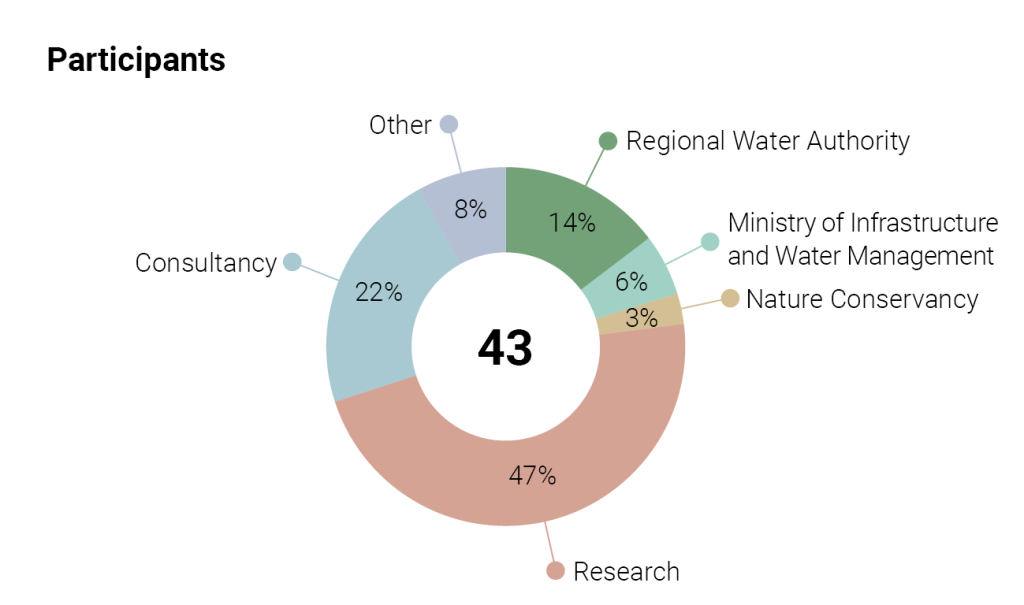
This reflection emerged from the discussion between the webinar team and the about 43 participants to the All-Risk webinar organised in June 29, 2021.
Would you like to view the presentations of the webinar team? You can view them in the above video.
Are marshes a realistic tool to manage flood safety?
After the presentations, we first discussed if marshes should be restored or created at the most wave-exposed places. Most participants thought that marsh restoration does have an added value for nature and flood safety but that marsh restoration at exposed places would require technical means. These means may involve the creation of traditional structures to create sediment accretion and drainage, in line with traditional solutions. But mimicry may also offer a solution (Temmink et al. 2021). Overall, only a few participants thought that marshes will not survive at exposed locations and that building with nature is not realistic there.
Subsequently, we discussed that marsh creation does not always improve the quality of nature, given that the tidal flats present now can be highly valuable too. For the additional value of tidal flats, waterboards tend to look seaward of a dike, while nature organisations see more opportunities for solutions landward of the dike. Finally, we pointed out that high marshes in a late-successional stage are most beneficial for flood safety, while young pioneer marshes have the most value for nature. The differences emphasise the need to create wide foreshores with low and high marshes being present, as they serve both goals and are more sustainable.
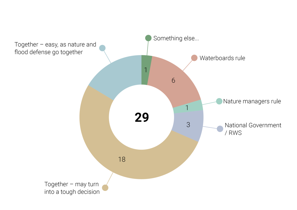
Participants responses to the question who should ultimately decide on foreshore management?
Who should be the responsible manager of the marshes?
We further discussed who should be responsible for managing the foreshores. Waterboards would prefer to be responsible because they are also responsible for flood safety, a primary requirement for the Netherlands. The department of Rijkswaterstaat prefers responsibility at a national level because the Wadden Sea is a national heritage, and local measures may have effects that go beyond the local scale. The nature organisations prefer a joined management responsibility to ascertain that the management will serve more than flood safety. An important remark from the contractors building dikes was that the management should be shaped realistically concerning long-term (maintenance) contracts. Nowadays, contracts are increasingly asking to offer construction and maintenance. If vegetated foreshores are part of the flood defence system, the management should allow maintenance works within the contracts.
Which kind of monitoring would be needed?
Inspired by the presentations, we discussed which monitoring strategies would be effective. Concerning the need to measure infragravity waves, opinions were split. On the one hand, participants noted that the uncertainties are small compared to the uncertainties in other dike-failure mechanisms, while the measurements are relatively expensive and with limited expertise available to interpret such infragravity wave data. The existing data sets of wave-boys should be analysed better. On the other hand, most participants like the basic concept that measuring equals knowing. Suppose there will be measurements to be done on infragravity waves. In that case, measurements should cover at least 2 locations: an area where infragravity waves are expected to be dominant versus an area where infragravity waves are expected to be unimportant based on present knowledge.
The participants were more positive about continuing the explicit spatial measurements of wave run-up using flotsam. It was noted that there is no need to measure continuously but that there needs to be a protocol to measure immediately following the rare major storms with large surges. Alternative measuring methods should be explored to enable more frequent monitoring. This alternative resulted in a lively discussion among waterboard participants. The bottom line seems that we all think there is a need for measurements as a knowledge base. However, protocols need to be standardised as much as possible across all parties involved.
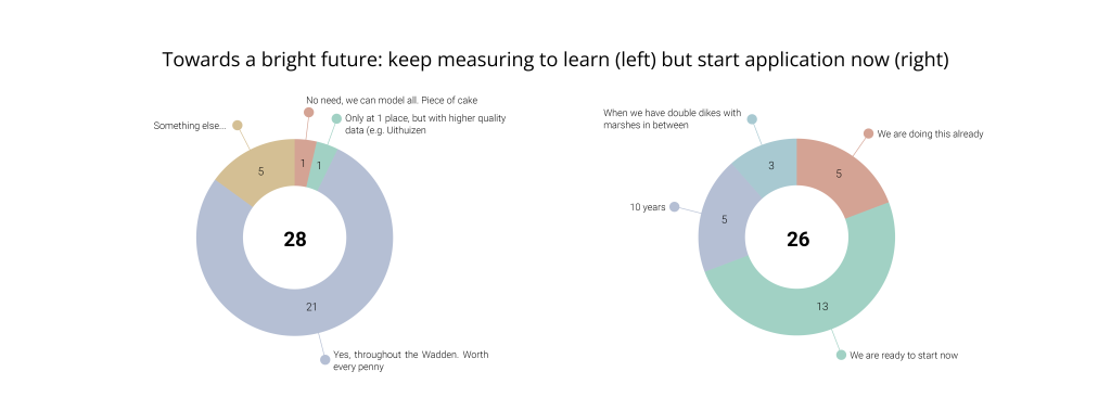
Participant responses to the questions - Left: Would it be useful to continue wave and floatsam measurements along the whole Wadden Coast to reduce uncertainties in wave attenuation? Right: How long will it take before we can actively design foreshores as part of our coastal defence scheme?
Where are the knowledge gaps?
Finally, we discussed if there are still major knowledge gaps hampering making designs and implementing foreshores in flood defence. It seems that there is sufficient knowledge to apply vegetated foreshores. The participants indicated that they had started or were ready to start. The most important remaining gap seems to be a lack of measurements on the efficiency in wave attenuation during superstorms and the long-term stability of salt marshes.
Nature managers emphasised that they prefer double-dike solutions with transitional polders above seaward solutions to preserve the valuable intertidal flats currently fronting the dikes. Given their protected status under EU law, seaward solutions seem difficult to realise. However, coastal protection is strongly based on Dutch law, so that tailor-made solutions may be necessary. Despite the sometimes opposing visions, there are especially opportunities to explore joined interests towards an applicable solution.
The main overarching outcome was that using vegetated foreshores for flood safety may be challenging. However, they offer promising opportunities for all partners to achieve (partly) both flood defence and nature goals and hence offer a perspective towards nature-based solutions. Implementation requires in-depth knowledge of the system. Thereby, we can get the vegetated foreshores where needed and manage them in a way that benefits both nature and flood safety.
All-Risk recommendations:
- Using vegetated foreshores (marshes) for flood safety offers many opportunities and raises questions about whom should be in charge of managing them. It would be worthwhile to initiate pilots to enable learning by doing shared management.
- Invest in spatial-explicit measurements of wave attenuation and wave run-up along the whole Wadden Sea coast. These measurements should include areas with and without vegetated foreshores focusing on the rare large (super)storms.
- Important to keep studying (1) how to construct marshes at wave-exposed areas and (2) which processes drive the long-term lateral dynamics of marshes.
- Seaward solutions are not everywhere applicable. Therefore, it is essential to start gaining a solid knowledge base on landward solutions, such as using transitional polders between double dikes.
Related projects


Last modified: 30/12/2021