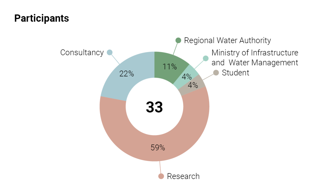
This reflection emerged from the discussion between the webinar team and the 33 participants to the All-Risk webinar organised in June 2, 2021.
Would you like to view the presentations of the researchers? You can view them in the above video.
Structure of the subsurface
The structure of the subsoil, the occurrence of sand and clay layers, and the characteristics of permeable sand layers are important preconditions for failure mechanisms of dikes, particularly for piping. The heterogeneity in the subsurface structure of the Rhine-Meuse delta results from the delta’s palaeo-geographical development and associated deposition of sediments. We can map this heterogeneity on different spatial scales using various source data. On the coarsest scale, the heterogeneity concerns the location of old rivers’ sand bodies across the delta. This information is contained in the GeoTOP data and is well known. On a more detailed scale, the heterogeneity includes local occurrences of sand lenses or other forms of local lithological differences that are difficult to detect. Cone penetration test (CPT) data and corings are now widely applied on this scale. However, these data remain ‘point’ observations; geophysical methods could provide an important addition here because they provide a full 2D profile of the subsurface structure and material properties. The condition is, of course, that geophysical data can be linked to subsurface properties, for example, by combining CPTs with a few boreholes. Therefore, the key question is, how can we better use subsurface information to improve the parameter estimates of models that determine the occurrence of piping, slide flow of channel banks, or other failure mechanisms of river dikes?
Discussion
What sources of information do we have
Users need subsurface information on a spatial scale of several meters in a horizontal direction. In the vertical direction, a much higher (decimeters, dm) resolution is required. As incorporated in GeoTOP, subsurface maps give a good picture of the lateral heterogeneity of the subsurface but give less detail in the vertical direction. Of the currently available data sources, there is a clear preference for corings and CPTs, with the detailed information from the CPTs being the most important. The cost of coring is significantly higher, core logs sometimes have less vertical detail, and only provide the necessary parameter values for the models after further laboratory analyses.
Combining CPTs with boreholes, supplemented with geophysical profiles, can provide the most spatial detail. Data from the boreholes serve to translate CPT results and geophysical profiles into lithology and parameters for the models. This translation could be done with direct 1-to-1 comparison at the core locations, via simple empirical relationships using data from multiple cores, or more refined (using local neural network techniques). The subsurface maps and GeoTop can then be used on a larger (> 100 m) scale to determine where the subsurface and its properties must be determined in more detail with local corings, CPTs and geophysical measurements.
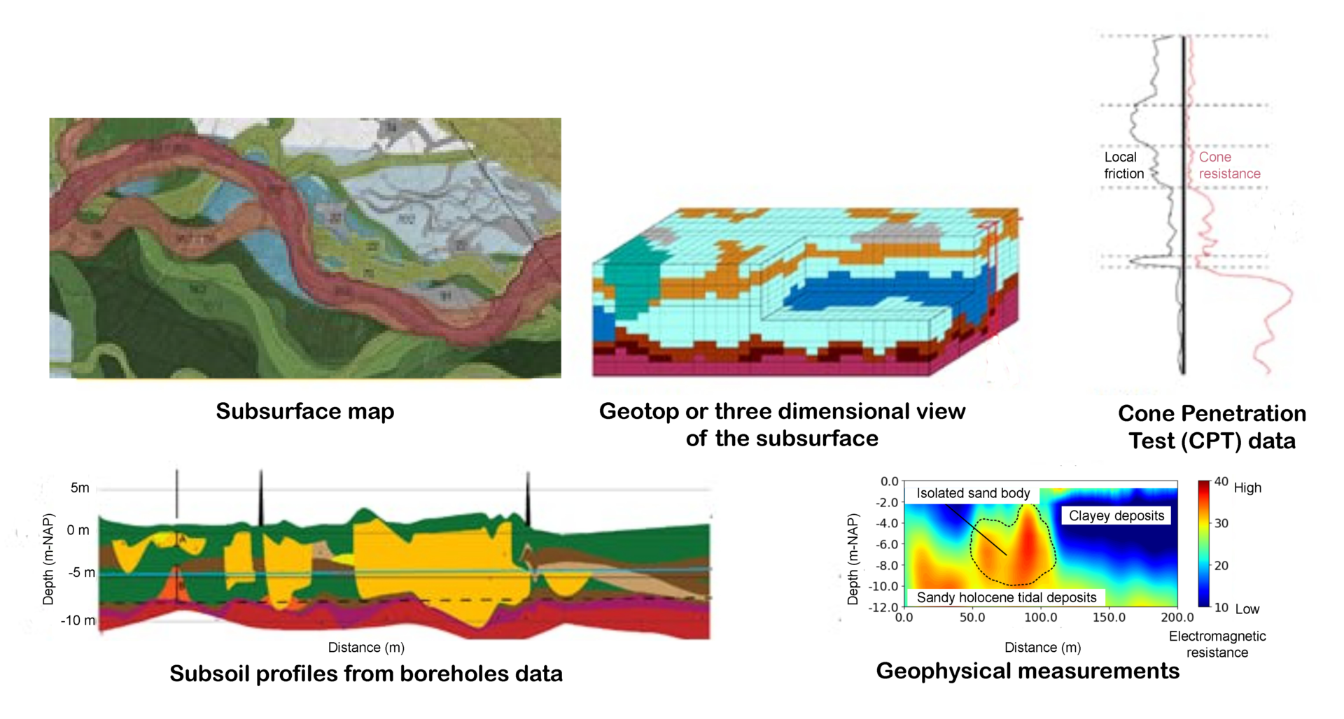
Snapshots of some of the available information to map the subsurface.
Barriers to implementation?
Participants mentioned several ‘technical’ barriers to applying this integration of sources in practice. In particular, standardisation of procedures, with uniform standards and guidelines, and ultimately including them in the Dutch national key registry of the subsurface (BRO), still require several steps to go. In addition, there are also non-technical barriers, including budget considerations, feasibility, experience and education, and acceptance of new methods.
Overall, the biggest challenge is seen in the mismatch between the data requirements and level of detail of current models applied to determine the occurrence of failure mechanisms on the one hand and the availability, resolution and quality of in-situ data from the field.
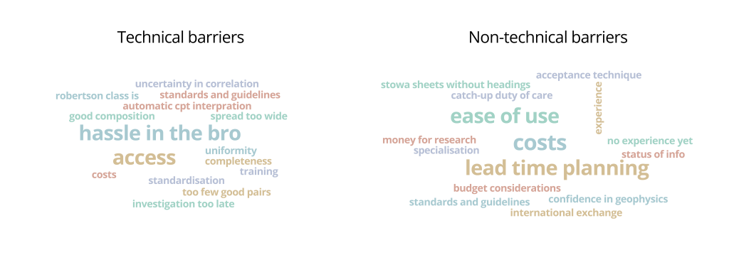
Participants responses to the questions what technical or non-technical barriers are there to using this information?
Conclusions and perspective
Considerable progress can be made by using a good representation of the subsurface, its structure and properties, as input for models that determine dike failure mechanisms. The gains will lie in detecting critical spots within the subsurface that require further detailed research and reducing the uncertainty of model parameters. ‘Large-scale’ information such as subsurface maps and GeoTOP can provide a good context for further local investigation. There are good opportunities in combining (cheap) CPTs, boreholes, and geophysical methods for the latter. The challenge is to translate CPT and geophysical data into information for models. Knowledge about the subsurface and how different types of sediment are formed can reduce uncertainty in model parameters at locations where such information is absent, for example, by a priori known differences in grain sizes between genetically different types of subsurface material. Geophysical methods are also ideally suited to detect very local and ‘unpredictable’ heterogeneities in the subsurface.
A major scientific challenge remains the mismatch between available information about the heterogeneous subsurface and the current models, their schematisation and required model parameters. It is important that we achieve improvement in surface information and application in the models, but that this can also be converted into a manageable method for application in practice for the managers, in which one can work with ‘standardised’ procedures.
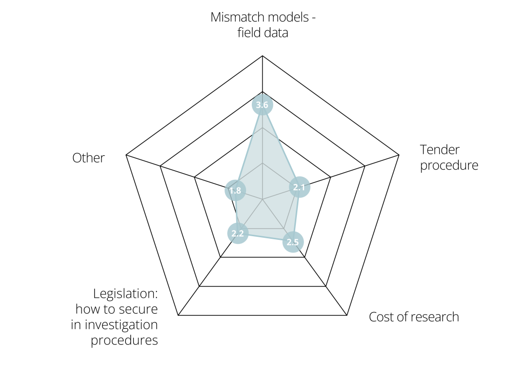
Participants response to the question where are the biggest challenges?
Testing current and new methods are difficult. We can explore how this can best be done by focusing on specific cases or dike trajectories where researchers work with the regional water authorities. In addition to subsurface data, we prefer to have data at our disposal that provide information about groundwater levels, groundwater flow, piping, etc., under extreme hydraulic conditions. This data allows us to learn how the dike system reacts under such conditions and where critical situations (can) arise. Extreme high-water peaks (such as this summer along the Meuse) are important events to collect such data, but these are rare. Nevertheless, collecting field data from past and future flood events remain important.
All-Risk recommendations
- Incorporate genetic knowledge (the ‘architectural elements’ building up the delta) of the subsurface to adopt a regional approach for more realistic and robust parameter estimates.
- Focus on a good parameterisation of architectural elements in risk assessments.
- Use prior subsurface knowledge for better streamlining of data acquisition by focusing these on critical areas.
- Combine point data measurements from cores and CPTs with geophysical data for improved and full-2D schematisation of the subsoil below dikes.
Related projects


Last modified: 07/01/2022