Outcome
The output of this project is better quantitative assessments of regional and local variability within different types of deposits (i.e. architectural elements) via critical subsurface characteristics. Overall, the subsurface architecture and associated sediment deposition conditions in which these elements form play an important role in, for example, scour holes or flow slide locations in the river channel nearby the dikes of the Rhine-Meuse delta. Relevant geotechnical properties show considerable local-scale differences leading to critical subsurface characteristics. These critical characteristics can be implemented within the subsurface schematisation for risk assessments to estimate more realistic parameters and reduce related uncertainties. Furthermore, this knowledge supports better allocation of resources for data surveys focusing on critical dike sections for failure mechanisms.
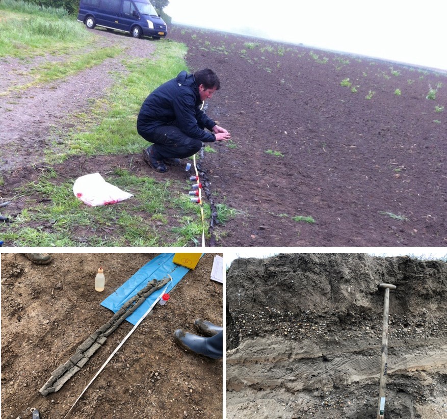
Figure 1. Fieldwork and subsurface data retrieval which is primary input for subsurface characterizations and reconstructions (Photos by Bas Knaake).
Motivation and practical challenge
Several dike failure mechanisms are related to the subsurface buildup, which shows a great spatial variability (see photos in Figure 1). However, current risk assessments rely on oversimplified subsurface properties. Owing to its depositional history, the subsurface shows systematic patterns. Geologic characterisations and reconstructions can provide important contextual information to reduce uncertainties in subsurface parameter estimates.
As earth scientists, we study sedimentology and the genetic history of the subsurface and associated processes. This project offers a great opportunity to integrate this knowledge to understand how the subsurface spatial distribution is related to several river channel and bank failure mechanisms, which may indirectly threaten dike stability, particularly where the dike is directly bordering the channel. This additional knowledge provides important insights into the geologic boundary conditions and relevant properties that are also relevant when designing flood defences.
Research challenge
This project integrates existing information and knowledge on the subsurface characteristics of the Rhine-Meuse delta in the Netherlands and relates that to failure mechanisms of river embankments.
Innovative components
Our research focuses on past occurrences of failure mechanisms such as (1) channel scour and (2) river bank failure (Figure 2, left). We particularly focus on the relation with subsurface architecture elements such as the former river channels (Figure 2, middle). This project assessed channel scour locations for all the major river branches of the Rhine-Meuse delta (Figure 2, right). For bank failures, we made use of an extensive historical database.
We compared locations where channel scours occur to existing geological mappings, such as locations of former river channels. Furthermore, we used 3D subsurface models of the TNO-Geological survey to map the regional and local buildup of the subsurface. These comparisons give important insight into critical subsurface characteristics for a failure mechanism.
Next, we focused on characterising deposits and the geotechnical properties for different architectural elements such as fluvial channel belts. These characterisations help better predict the potential risk areas for a failure mechanism, leading to a more efficient design of flood defences.
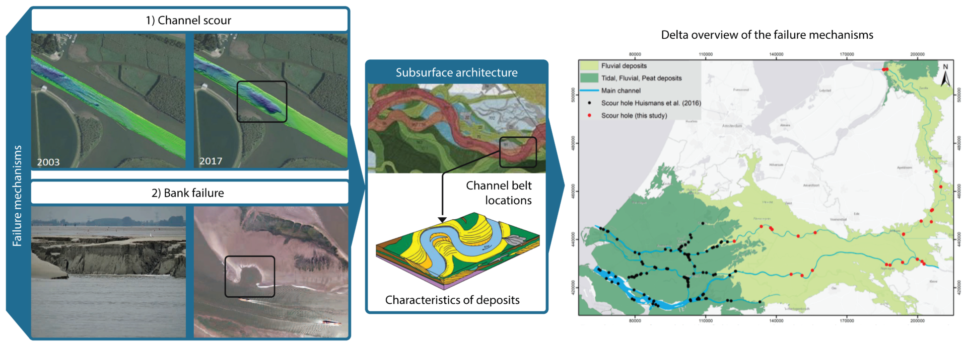
Figure 2. Main components of the research (source: photos bank failure by Deltares, middle-figure by Kim Cohen and right figure adapted from Gouw, 2007 and overview map from Knaake et al. 2019).
Relevant for whom and where?
The history and origin of the subsurface can help advisors and management organisations identify potential risk areas for a failure mechanism when planning or implementing river measures such as dike reinforcements.
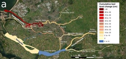
This project assessed the major river branches of the Rhine-Meuse delta until the Western Scheldt. On the map, Dordtsche Kil branch, near the city of Dordrecht which is referred as example on the progress results.
Progress and practical application
The results show that scour holes in the Rhine-Meuse delta have a clear link with subsurface architecture and associated depositional history. The downstream area is characterised by high variability in erodible and non-erodible materials. As a result, a sharp increase in scour hole frequency is observed. This relation is especially clear for the Dordtsche Kil branch, near the city of Dordrecht, where subsurface architecture strongly influences the river bathymetry. Due to its depositional history, the northern part of the Dordtsche Kil branch is characterised by an erosion-resistant, stiff clay layer that is locally dissected by former river channels. Instead, the southern part consists of much more homogeneous sand. Resulting from this subsurface architecture, the bathymetry of the northern part of the Dordtsche Kil branch is characterised by local scour holes, and the southern part is much more homogeneous in depth. For details on the results, see the related outputs.
Recommendations for practice
- Incorporate genetic knowledge (i.e. architectural elements) of the subsurface to adopt a more regional approach for more realistic parameter estimates making risk assessments less sensitive to potential outliers within local subsurface data.
- Focus on the good parameterisation (i.e. realistic parameter estimates) of architectural elements for risk assessments.
- Use prior subsurface knowledge for better streamlining data acquisition by focusing field surveys on the more critical areas.
Last modified: 23/12/2021
Contributing researchers

Bas Knaake
Utrecht University


User group


Project outputs
Anthropogenic effects on the Contemporary Sediment Budget of the Lower Rhine-Meuse Delta Channel Network
The Rhine-Meuse Delta has a negative budget: Its entire network of channels is losing sediment annually. The reason for this negative budget is the high amounts of sand and mud removed for navigation to inland ports and from harbors which are periodically dredged. A strategy is required to deal with channel degradation and find ways to maintain sediment in the system.
10/06/2021 by Bas Knaake et al.
![]()
Bevat: Publication open access journal
Geological framework for assessing variability in subsurface piping parameters underneath dikes in the Rhine-Meuse delta, the Netherlands
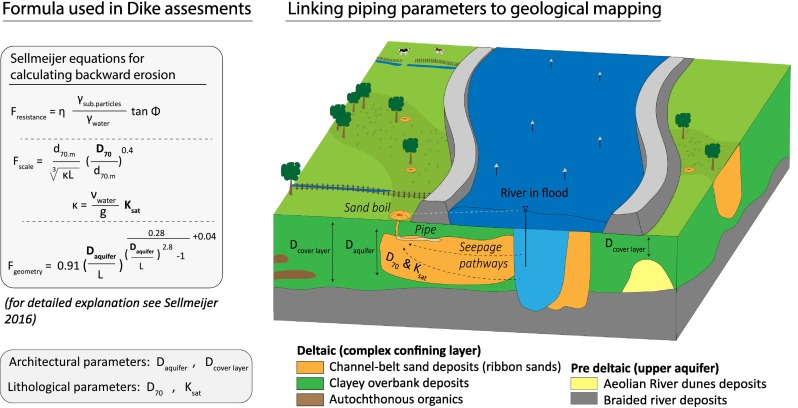
Downstream fining of D50 top sand values is caused by drops in specific stream power. Sediment inheritance, through reworking of pre-deltaic sands causes local variations in D50 top sand values.
05/12/2021 by Bas Knaake et al.
![]()
Bevat: Publication open access journal
- S.M. Knaake, M.W. Straatsma, Y.Huismans, K.M. Cohen, E. Stouthamer, H. Middelkoop (in review.) The influence of subsurface archi-tecture on scour hole development in the Rhine-Meuse delta, the Netherlands.
- S.M. Knaake, K.M. Cohen, T.A.A. van Woer-kom, H. Middelkoop, E. Stouthamer (in prep). Estimating flow slide susceptibility of heterogeneous channel banks from subsurface architecture.
- S.M. Knaake, K.M. Cohen, H. Middelkoop, E. Stouthamer (in prep). Implications of regional variability and associated uncertainties for the susceptibility to dike failure mechanisms resulting from delta-scale subsurface architecture.
- S.M. Knaake & T.A.A. van Woerkom (in prep) Influence of subsurface architecture and as-sociated parameters on groundwater conditions and stability.
- S.M. Knaake, M.W. Straatsma, Y.Huismans, K.M. Cohen, E. Stouthamer, H. Middelkoop (2020). Relating scour hole development to subsurface heterogeneity of the Rhine-Meuse delta, the Netherlands. NCR Abstract.
- S.M. Knaake, M.W. Straatsma, Y.Huismans, K.M. Cohen, E. Stouthamer, H. Middelkoop (2019). The influence of subsurface heterogeneity on scour hole development in the Rhine-Meuse delta, the Netherlands. NCR Abstract.
Events
02/06/2021
Reflection: Better mapping of the subsurface
How can we make better use of subsurface information to improve the parameter estimates of models that determine the occurrence of piping, slide flow of channel banks or other failure mechanisms of river dikes?