


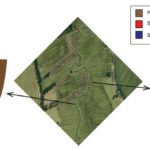
Top: Maps of the Overijsselse Vecht showing the location of the study sites Junnerkoeland and Prathoek.
Bottom: Digital elevation model of the two locations indicating the data collected. (Source: Figure 1; Candel et al. 2018)
Innovative components
Historical changes may pass unnoticed unless the origins of the sediment bars and river channel are documented with field data. We developed a methodology to reconstruct the profile of river deposits and calculate the historical discharge. We tested our approach in the Overijsselse Vecht river in which lateral activity of 500 years ago caused spectacular meandering by using field collected data to map the river profile and sediment bars from this study and Quik and Wallinga (2018). We calculated the standard discharge relationships based on the historical analysis. We finally estimated the errors and uncertainty of our calculations based on the variability of input parameters.
Findings and implications to practice
The meander of the Overijsselse was caused by an increase in the peak discharges during the Little Ice Age. In addition, the catchment area of the Overijsselse Vecht comprised 27% of peat, which had the function to absorbe high water discharges during intensive precipitation. However, due to human interventions from the 14th to the 17th century, agriculture and excavations for peat extraction led the peat to disappear, and flood discharges in the river to increase. Thereby, stream restoration projects could learn from this historical case that redevelopment of a stream and river valleys requires a catchment area approach.
Related Content
Publication
- Candel, J. H. J., Kleinhans, M. G., Makaske, B., Hoek, W. Z., Quik, C., & Wallinga, J. (2018). Late Holocene channel pattern change from laterally stable to meandering – a palaeohydrological reconstruction. Earth Surface Dynamics, 6(3), 723–741. https://doi.org/10.5194/esurf-6-723-2018
- Quik, C., & Wallinga, J. (2018). Reconstructing lateral migration rates in meandering systems – a novel Bayesian approach combining optically stimulated luminescence (OSL) dating and historical maps. Earth Surface Dynamics, 6(3), 705–721. https://doi.org/10.5194/esurf-6-705-2018
- Here is available the full list of related conference abstracts related to this project.
(Under) Graduate thesis
- Verplak, M. (in press.). “Human influence on the Overijsselse Vecht”. MSc. thesis, Wageningen University & Research. (student project)
- Steijsiger, E. (2018). “Illuminating the history of fluvial sediments”. MSc. thesis, Wageningen University & Research. (student project
Dataset access
Example data and a calculation spreadsheet following the presented method in this research are available in the Supplement of the publication and it is available online at: https://doi.org/10.5194/esurf-6-723-2018-supplement.
Related outputs
Oblique aggradation: a novel explanation for sinuosity of low‐energy streams in peat‐filled valley systems
We inform stream restoration in peat-filled valleys by looking at the relative position of the erodible material to explain the origin of the stream bends in the Drentsche Aa area.
07/12/2016 by Jasper Candel et al.
![]()
Contains: Dataset access Publication open access Storyline for practice
Last modified: 30/01/2019